Last Updated on January 20, 2025
We get it. You can laze around the beach for only so long. Luckily, Maui offers a lot more than sand and sea. There are plenty of opportunities to explore the island’s diverse and lush landscape on foot.
This post contains affiliate links. By purchasing through these links, we may receive a small commission at no additional cost to you. Maui Trip Guide is also a participant in the Amazon.com Associates Program. As an Amazon Associate, we earn from qualifying purchases.
We narrowed down the list to six trails that first-time visitors will want to check out. Some are fairly challenging, while others feel more like a leisurely stroll. But all of the hikes showcase some of Maui’s greatest assets, from views above the clouds to sacred, historical Hawaiian sites.
Lace up those hiking shoes — and don’t forget to pack water and bug spray.
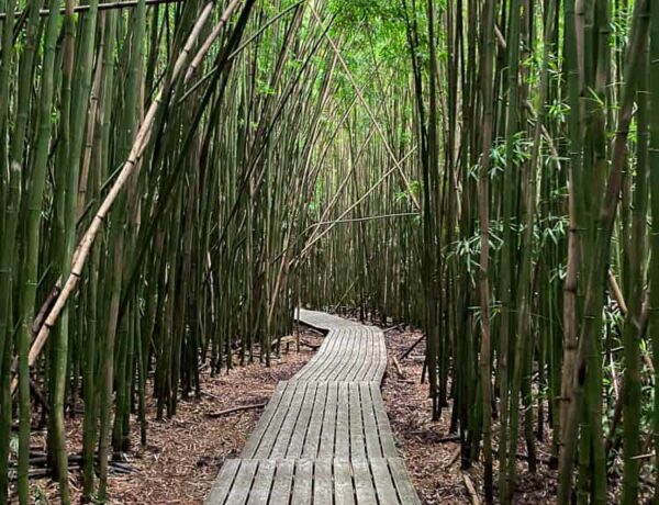
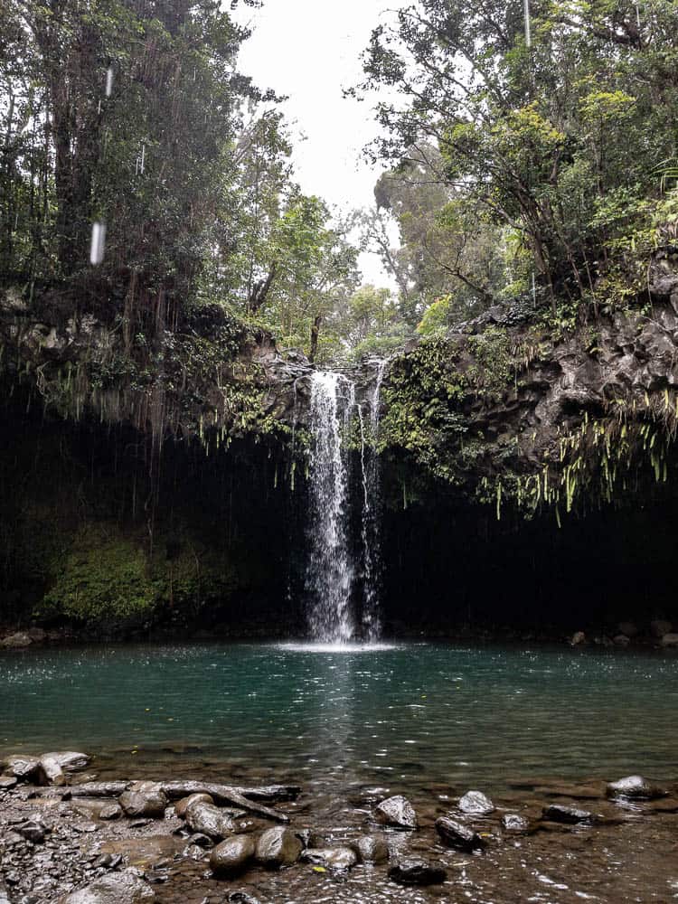
Pipiwai Trail


Why we love it: You’ve probably scrolled past photos of this Instagram-famous trail at some point. The boardwalk winding through the bamboo thicket at Pipiwai Trail has become a trademark for Maui vacation photos, and for good reason.
This 4-mile hike past Hana along Hana Highway highlights the island’s diverse flora and fauna: a sprawling banyan tree, the melody of bamboo branches in the wind, and a waterfall at the turnaround point.
Getting there: The Kīpahulu District, where Pipiwai Trail sits, is part of Haleakala State Park. But this section of the park is only accessible by car along Hana Highway, on the east side of the island.
From Hana Highway, turn into the parking lot at these coordinates: 20.660797, -156.046646 / 20°39’38.9″N 156°02’47.9″W.
Entry and parking fees: $30 park entry. No additional fee to access the hiking trail. You can also use your receipt to re-enter Haleakala State Park at the summit side within 3 days.
Hours: 9:00 a.m. to 5:00 p.m. Entry gate closes at 4:30 p.m.
How long is the Pipiwai Trail? The trail is 4 miles long with 800 feet in elevation change.
How long does it take to hike Pipiwai? It t akes 2-2.5 hours round trip if you’re hiking to the waterfall and back. If you hike just to the bamboo forest and decide not to continue to the waterfall, allot 1 hour round trip.
How hard is the Pipiwai trail? The National Park Service rates the trail as moderately strenuous. There’s an initial hill climb with sets of stairs and sections of steep grades for the first half mile or so.
Do you need hiking shoes on Pipiwai Trail? You’ll do fine wearing sneakers or other comfortable closed-to shoes. While you could make it in sandals, we wouldn’t recommend it. The trail is uneven, and you’d probably end up caked in mud.
Can you swim on Pipiwai trail? When we last visited, we noted signage that Waimoku Falls is closed for swimming.
Pro tip: Pipiwai’s a popular tourist trail with heavy food traffic, so get there early to avoid the crowds. And while the trail stays open year round, prepare for mud if it has rained recently.
Looking for other things to do along the Road to Hana? Pipiwai Trail is one of our favorite stops to make when we drive the Hana Highway. Check out our curated list of the best 18 stops to make on the Road to Hana.
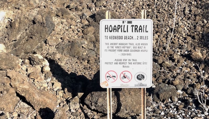
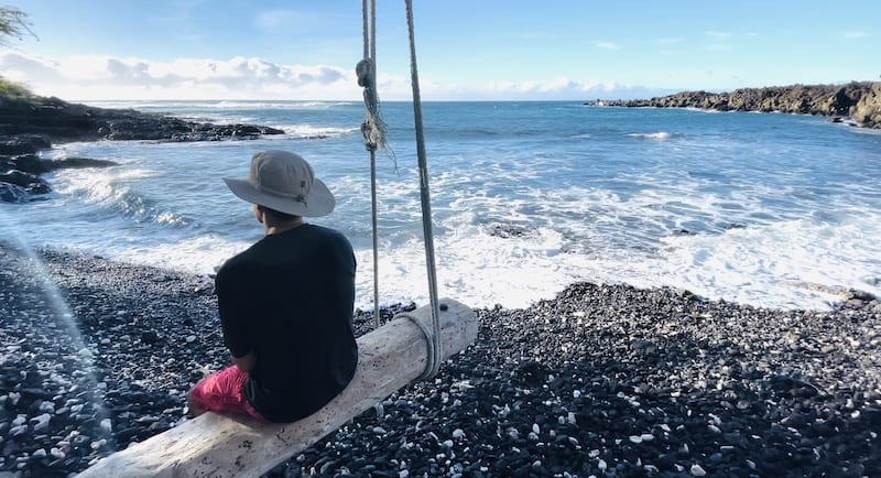
Hoapili Trail at La Perouse Bay

Why we love it: If you’re looking for a hike that’s a stark contrast from the typical tropical forest hikes, consider Hoapili Trail in South Maui. You’ll start at La Perouse Bay, where spinner dolphins are known to make an appearance among snorkelers.
Then traverse a 2-mile trail of loose softball-sized lava stones to one of the most secluded and breathtaking beaches — Kanaio Beach. Savor the solitude.
The downside? It’s not the easiest journey. This trail doesn’t get as crowded as other hikes because fewer tourists are willing to take the challenge. Besides the loose lava rock that could turn your ankle at any step, prepare for unrelenting elements: sun and wind.
Startled by sudden movement in the brush near the start of the trail? Don’t worry, the resident free-roaming goats keep their distance.
How to get there: Drive south on Makena Road past the lava fields until the bumpy asphalt ends to a dirt road. Then veer right toward the ocean. Follow the gravel road to an open parking lot. You’ll see portable toilets and a large refuse container. Park where space is available. There’s also street parking just before Makena Road ends.
Use GPS coordinates 20.599485817945514, -156.41984682943124.
Trail map: Link
Entry and parking fees: None
How long is the Hoapili Trail? It’s a little over two miles from the La Perouse parking lot to Kanaio Beach. We logged 4.5 miles out and back after turning around at Kanaio Beach.
Another option is to hike along the coast to the Hanomanioa Light, which is approximately 1.5 miles from the parking lot.

How long does it take to hike? It took us 2 hours to hike from the parking lot to Kanaio Beach and back.
How hard is the Hoapili hike? The Hawaii Department of Land and National Resources rates the Hoapili Trail as difficult.
We won’t lie, this hike was a doozy. It’s pretty much flat, but the rocky terrain was a challenge. We don’t recommend this hike if you have weak ankles. Also, keep in mind that you’re exposed to both the wind and sun during most of the hike.
Do you need hiking shoes? We highly recommend hiking shoes for the Hoapili hike. The trail consists of large, loose rocks that can easily twist an ankle. Also, the rough lava rock can tear up the soles of your footwear. Sturdy hiking shoes (preferably boots) are your best bet.
Can you snorkel on this hike? The trailhead begins at La Perouse Bay, which is part of Ahihi Kinau Natural Area Reserve. The area tends to have strong winds and surf, and there are no lifeguards. We’d recommend this area for experienced swimmers and snorkelers only.

Pro tip: Bring a hat and start your hike early to avoid the sweltering heat of midday. You’ll get plenty of windy breeze on this hike, but the lava rocks absorb and reflect heat from the sun. A hat will offer some protection from exposure.
Twin Falls
Why we love it: Twin Falls is the first main stop along the Road to Hana (if you’re driving east from Kahului), making it easy to get to. The hike itself is short and relatively easy. And you can swim at the base of a waterfall. And while the stop is called Twin Falls, there are more than two waterfalls to hike to in the area. To top it off, you can load up on yummy snacks from the farm stand.
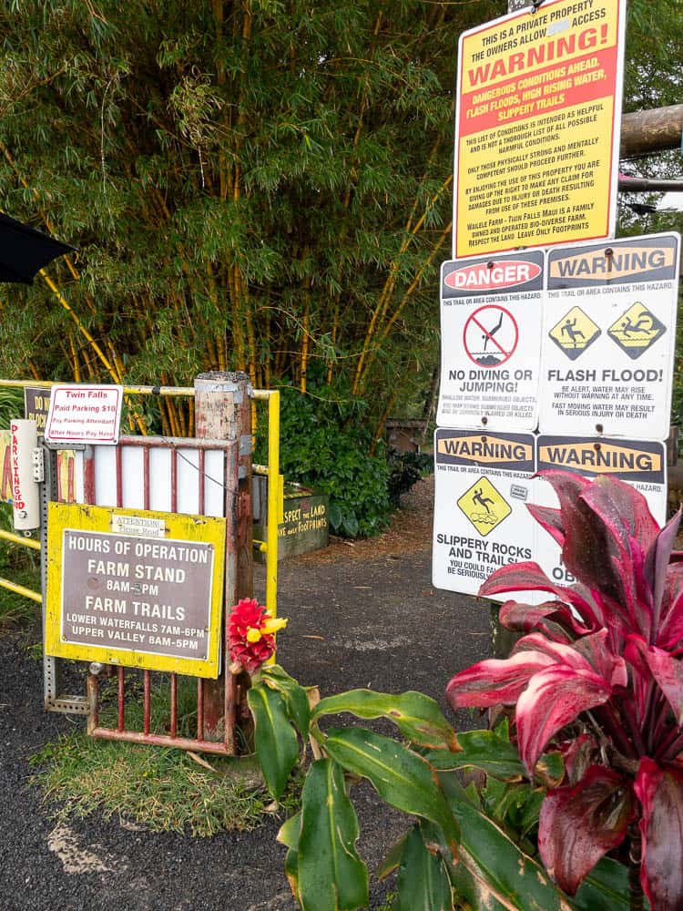
Drawbacks: The Twin Falls trail gets incredibly crowded! Because of the steep rise in tourism, the property owners have implemented parking fees as of 2020.
And while the trail generally remains open year round, parts of the trail may close due to weather and flash flood warnings. Check the Twin Falls Instagram account for updates on trail closures.
How to get there: Coming from Kahului, drive toward Hana on the Hana Highway. After mile marker 2.0, turn into the parking lot at the right. Parking is limited. But do not attempt to park on the bridge!
Entry and parking fees: $10 per car. Be courteous to the parking attendant, or they may deny you a parking space and refuse entry. This hike isn’t a public park. You can only access the falls via private land.
How long is the Twin Falls hike? The trail is around 1.8 miles round trip.
How long does it take to hike Twin Falls? Hiking to both the upper and lower falls takes around 1.5 hours round trip.
How hard is the Twin Falls Hike? Some trail guides rate the hike as moderate, but we think it’s a fairly easy hike. You’ll need to navigate past a shallow stream to get to the upper falls, so you may get wet.
Do you need hiking shoes? No, you can get away with hiking this trail in sandals. If you hike to the upper falls you’ll end up crossing shallow water, so water shoes are a good idea.
Can you swim on the Twin Falls hike? Yes, you can swim at the falls.
Piilani Trail at the Black Sand Beach


Why we love it: Squish your toes in black sand and marvel at the coastal views on the north side of Maui. The Piilani Trail winds through Wai’anapanapa State Park, where you can explore lava rock, a sea arch, and blowhole.
How to get there: Head east on Highway 360 (Hana Highway) from Kahului airport. Make a left just past mile marker 32 onto Honokalani Road. Follow the road past the residential homes until you reach the end of the road at Wai’anapanapa State Park.
Entry and parking fees: Non-Hawaii residents pay $10 per vehicle for parking AND an entry fee of $5 per person. No entry fee for children age 3 and under. Visitors must also make an advance reservation online for a specific date and time frame.
There is no charge for Maui residents.
Hours: The park is open daily from 7:00 a.m. to 6:00 p.m.
How long is the Piilani Trail? The Piilani Trail is 3 miles round trip.
How long does it take to hike? It takes around 2 hours to complete the Piilani Trail hike heading southbound and back to the state park.
How hard is the Piilani trail hike? We rate the Piilani trail easy to moderate. While there isn’t much elevation gain, the terrain is uneven with lava rocks and slippery sections where wet.
Do you need hiking shoes? We recommend sneakers or hiking shoes for this hike.
Can you swim on the Piilani Trail hike? You can take a dip in the ocean, but bear in mind that water can get rough at this section of coastline. There are no lifeguards. Swim at your own risk.
Do you have to have a reservation to hike the Piilani Trail? Yes, you need a reservation to access Waianapanapa State Park, which is where the Piilani Trail lies.
Iao Valley State Park


Why we love it: Hard core hikers won’t be impressed with this short and sweet hike. Still, it’s a spot worth exploring if you’re in the area, or prefer an easygoing nature walk.
Visit for the area’s cultural significance and spiritually lifting landscape. The park is a sacred space and resting place for ancient Hawaiian chiefs.
The Iao Valley needle, a 1,200-foot erosional feature, towers above the tropical valley for delightful views. With the lush green landscape and bubbling stream, it feels like a T-Rex could emerge from the trees at any moment.
Unofficial hiking trails exist beyond the paved overlook trail, but we don’t recommend trespassing beyond the signs. Beyond the public trails, the makeshift paths aren’t maintained. And since the the Iao Valley is known for its rainfall, the trails can become slick. Falling rocks are also a hazard in the valley.
How to get there: From Kihei, take the Honoapiilani Highway (Highway 30) northbound to Main Street. Turn left on Main Street. After 0.5 miles, stay to the right of the fork onto Iao Valley Road. Follow Iao Valley Road for approximately 2 miles until you reach the parking lot.
Parking lot coordinates: 20°52’52.3″N 156°32’41.0″W
Entry and parking fees: Non-residents $5 per person entry and $10 parking fee for non-commercial vehicles.
Hours: Daily 7 a.m. to 6 p.m.
How long is the Iao Valley scenic hike? It’s 0.6 miles to the Iao Valley scenic overlook.
How long does it take to hike? It should take no more than an hour to complete the walk, depending on how fast you go and how frequently you stop.
How much time do you need for Iao Valley? Two hours should give you plenty of time to take a leisurely walk to the viewpoint, have a look at the botanical area, and explore the stream.
Is the Iao Valley a hard hike? No, the Iao Valley lookout hike is a relatively easy walk. There isn’t much of an elevation gain, and it’s pretty short. But the landscape and views are gorgeous.
Do you need hiking shoes? Getting to the scenic overlook is via a paved trail, so you won’t need hiking shoes on for this route.
Can you swim at Iao Valley? Yes, you could take a dip in the stream along the trail. We saw several people wading into the cool water during our last visit.
However, DLNR doesn’t recommend swimming in the Iao Valley stream. Not only are the river rocks slippery, but the water flows quickly with danger of flash flooding. As with any hike, use caution and heed signage.
Waihee Ridge Trail
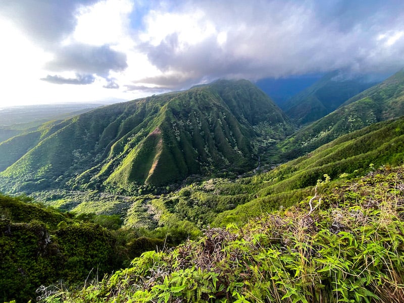
Why we love it
Get your heart pumping while you hike into the clouds at Waihee Ridge. If you’re not socked in with rainclouds, you’ll find spectacular views from the ridge peak.
The ridge lies on the windward side of Maui, which rains more than other areas of the island. So watch out for slick and muddy trails. Because of its popularity with visitors, Waihee Ridge remains a groomed and well-worn trail.
We recommend arriving early to avoid being relegated to the lower parking lot, which adds another 0.9 miles to the hike.
How to get there: Take Kahekili Highway (Hwy 340) and turn on Maluhia Road. The turn is easy to miss — It’s across the street from Mendes Ranch.
Drive past the overflow parking lot for 0.9 miles to the main parking lot.
Entry and parking fees: None

Hours: Daily, 7:00 a.m. to 7:00 p.m.
How long is the Waihee Ridge Trail? The DLNR lists the official trail length as 5 miles out and back. But we logged it closer to 4 miles with an elevation gain of around 1,500 feet.
How long does it take to hike the Waihee Ridge Trail? Allow for 2.5 hours to 3 hours to complete the Waihee Ridge Trail hike.
How hard is the Waihee Ridge Trail hike? The elevation gain can be a moderate challenge for hikers, and the trail can be slippery in wet weather. The trail itself is groomed and well worn due to the number of hikers.
Do you need hiking shoes on the Waihee Ridge Trail? We recommend hiking shoes, especially if it’s rained recently. You can also get away with hiking in sneakers.
Can you swim on the Waihee Ridge Trail? No, there aren’t any water features along this hike for swimming.